Unlocking True Water Risk Assessment Worldwide
by Alex Truby, Ava Jordan and Heiko Udluft
Unlocking True Water Risk Assessment Across Insurance, Finance, Public Safety, and Beyond
Check out the solution accelerator to download the notebooks referred to throughout this blog.
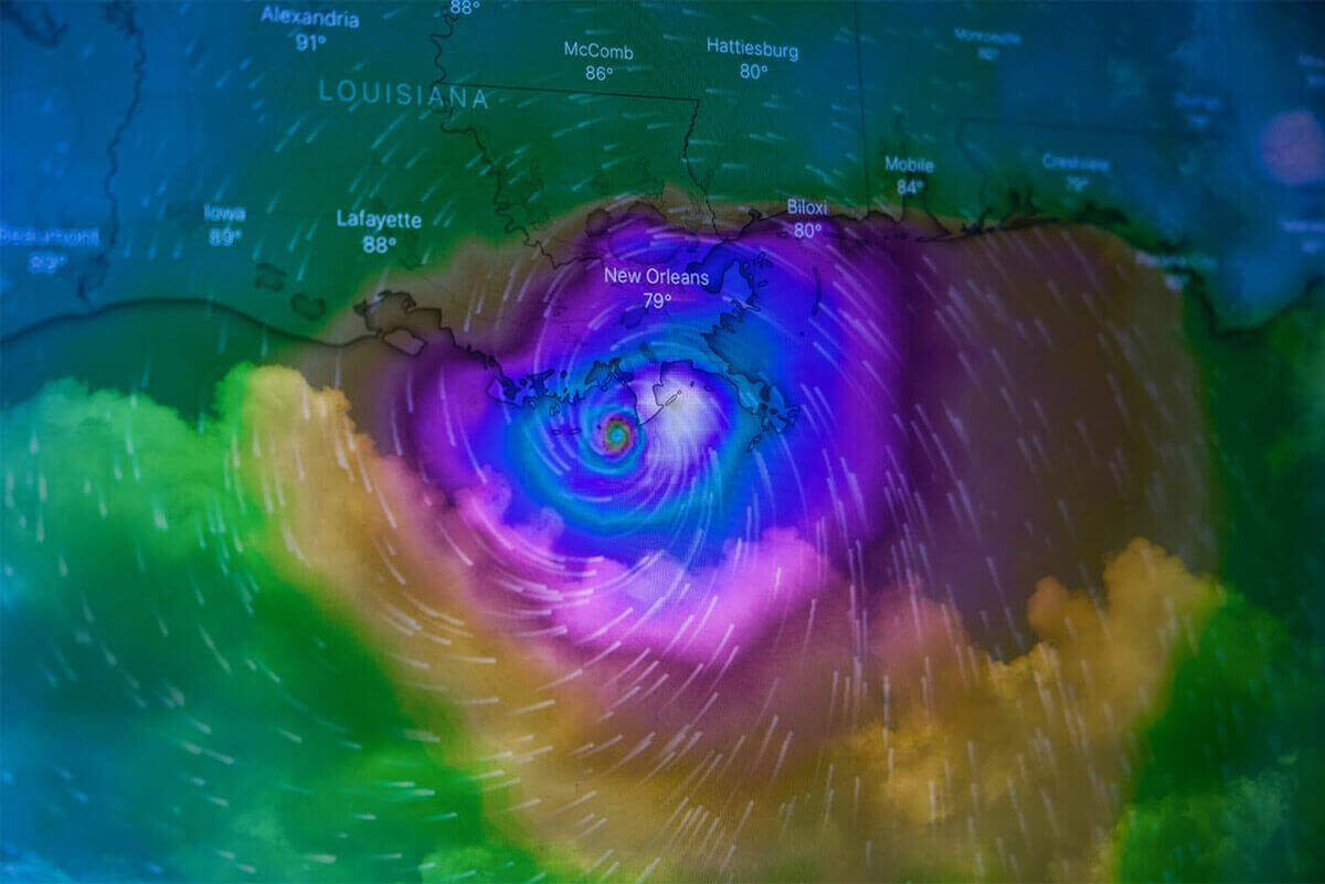
Water and climate change are inextricably linked, and It's apparent that the cost of inaction outweighs the costs of action. Over the past 40 years, the United States has faced a mounting financial burden of over $2 trillion in recovery costs due to the dramatic increase in large-scale climate disasters. In 2023 alone, the US tallied a price tag of at least $92.9 billion. The World Meteorologic Organization (WMO) reported that the number of floods has increased by an alarming 134% in the last two decades, while the incidence of droughts has risen by 29%. Communities and assets worldwide are facing substantial risks from both water excess and scarcity.
Effective water risk management requires real-time water risk data to be continuously fed into risk models. Real-time water risk data is a stream of empirical measurements collected (from rivers, lakes, reservoirs, groundwater, or precipitation) and reported which empowers you to "respond" in "real time." Precise up-to-date water risk data enables proactive decision-making, improves resource allocation, and helps mitigate the adverse impacts of water-related events, ultimately contributing to economic resilience and sustainability for emergency response, critical infrastructure, investors, insurance, and beyond.
Without continuously updated water risk data, we rely on outdated or hypothetical data fed into models, creating a world of misunderstood and misrepresented risks, preventable destruction, and even fatalities. Yet, real-time water risk data scarcity bleeds into nearly every industry. We observe the effects of water risk data scarcity in insurance, by affecting the accuracy of flood risk assessments; in the finance sector, when investment and development decisions are impacted by inadequate water risk data; and with public safety and disaster management, when disaster preparedness and response are delayed by lack of access to continuous real-time water risk data.
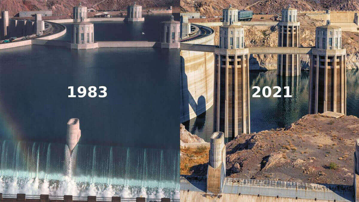
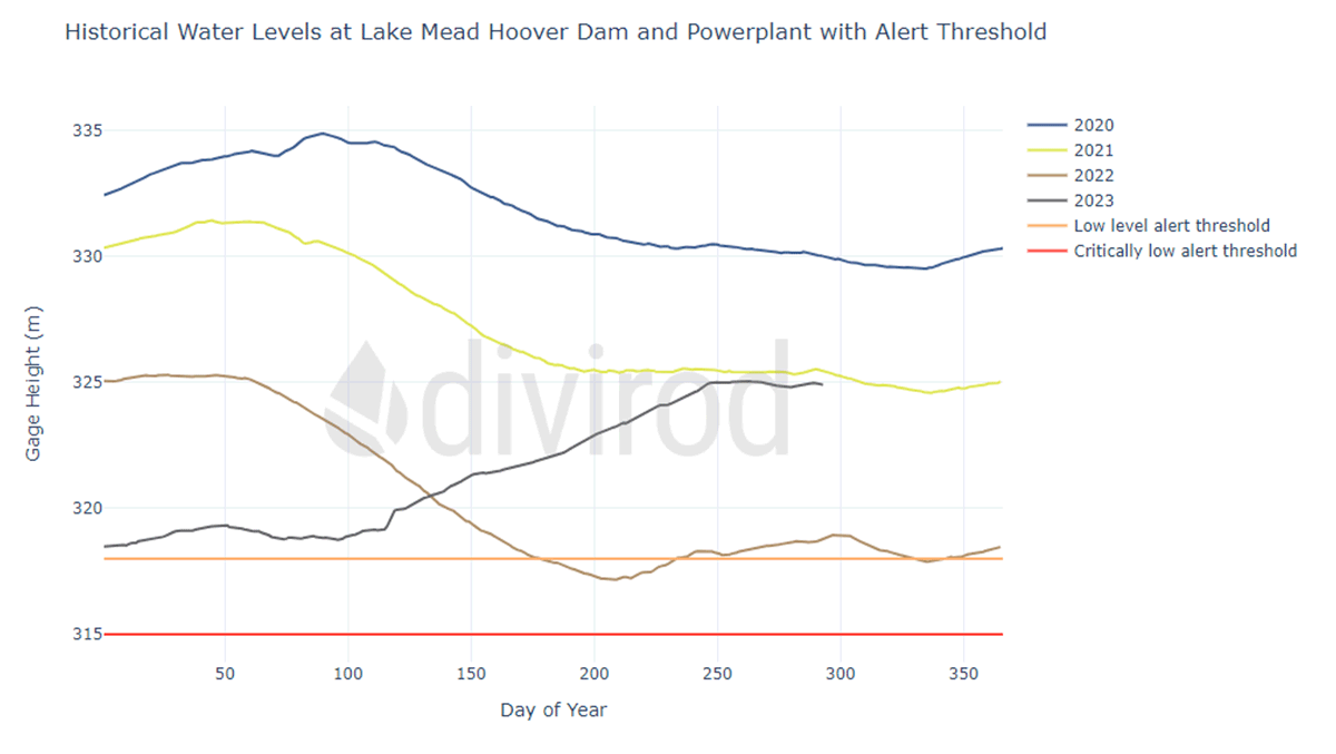
The picture above shows the change in water level at the Hoover Dam within 40 years. This example illustrates how significantly and rapidly water levels and therefore water risks are changing. This rapid change motivates the use of up-to-date datasets that capture changes and trends in water risk.
A closer look at water risk data scarcity is in the flood risk management space. Those purchasing property or underwriting flood risks often rely on the Federal Emergency Management Agency's (FEMA) 100-year floodplain maps. While FEMA maps are important tools for informing response plans, floodplain management, and for setting insurance rates, they rely on past events (three-quarters of the maps are more than five years old). These maps do not account for recent changes in sea level rise, rainfall, localized trends, or riverine flooding, resulting in inaccurate models, flood insurance premiums and vulnerable properties.
Divirod's novel approach to true water risk assessment
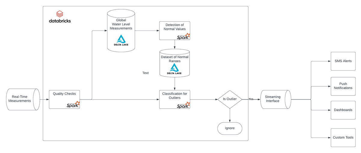
Gone are the days of relying on data estimations, outdated maps, and imprecise models. Divirod, a climate-tech startup based out of Colorado, is combating water data scarcity and revolutionizing water risk assessment worldwide. By leveraging Databricks' unique ecosystem of tools, Divirod processes 30 million water measurements daily from diverse sources using Spark Streaming, to build the world's largest water risk data lake with billions of unified real-time data series across 20,000+ locations. Divirod's robust data lake, containing an archive of up to 100 years of data through Delta Lake technology, empowers Data Scientists to efficiently analyze data and integrate it into analytics tools via Delta Sharing and Unity Catalog, and running sub-second queries with Databricks Serverless SQL Warehouse.
With the vision to revolutionize our world's approach to water risk assessment across every industry, how does one begin to quickly transform potential into value? Divirod's approach redefines water risk assessment by continuously establishing normal ranges of water level for each location within their data lake. This process of defining 'normal' ranges enables the identification of anomalies, such as sudden spikes or dips in water levels, abnormal flow rates, or unexpected weather patterns.
Divirod's solution accelerator solves three problems of working with water risks:
- Setting and maintaining baselines for every location in our data lake (including seasonal trends)
- Providing prebuilt logic to understand when water levels are "much lower or higher than normal"
- Continuously monitoring in real-time for such deviations and providing notifications in real-time
While feasible, solving these problems on your own requires significant manual effort, time, and resources. This accelerator enables the user to start layering in their unique location to determine how these abnormalities uniquely impact the area of concern. From risk assessment and claims support in insurance, disaster preparedness efforts and public safety decisions in communities, to informing investment decisions in finance - Divirod's solution accelerator equips users to effortlessly identify when water levels are 'normal,'- Divirod's solution accelerator equips users to effortlessly identify when water levels are 'normal', thereby bolstering resilience, confidence, and integrity in the face of water-related challenges.
Getting Started with Divirod's Outlier Detection in Water Data Solution Accelerator
Imagine what value you could unlock if you had...
- Access to the quality-controlled and ready-to-be queried Divirod Data Lake with over 2Bn measurements that is growing at a rate of 30M measurements per day
- Access to granular historical data capturing, seasonality, annual trends, and global long-term changes
- Access to the growing list of proprietary locations with continuous real-time measurements
- Access to pre-built outlier detection model
Get started today by importing this solution accelerator directly into your Databricks workspace. Once imported you will have notebooks with three pipelines ready to move to production.
- Implementation of Quality Checks (simplified version of proprietary method)
- Implementation of WLI Method for "Normal Value" Detection [https://wli.divirod.com/methodology.pdf]databricks
- Implementation of Outlier Classification
With three pipelines, you can begin understanding and analyzing outliers in water datasets with minimal effort. This solution accelerator also provides a foundation to build, customize and improve the model with relevant data to water and your interests.
Check out the solution accelerator to download the notebooks referred to throughout this blog.
Get the latest posts in your inbox
Subscribe to our blog and get the latest posts delivered to your inbox.